


To Print PDF: Step 1) Expand to full screen view (click box in top right hand corner of map). Step 2) Zoom in to your desired map section view. Step 3) Click on the three white vertical dots and then "Print Map" from that drop down menu.
Trail Overview

Length: 425 miles
Time to hike: 1 month (give or take a week)
Start point: the south jetty of the Columbia River at Fort Stevens State Park in Northern Oregon
Endpoint: Crissey Field State Recreation Site at the California border (just south of the “Welcome to California” sign)
Highest Elevation: Neahkahnie Mountain (1680 feet)
Lowest Elevation: sea level (0 feet)
In 1959, a local geology professor named Samuel Dicken walked the Oregon Coast and envisioned a unified trail to connect Washington and California. Because the trail features extensive beach hiking, the 1967 Oregon Beach Bill, which specified that all beaches were public up to the vegetation line, allowed his vision to become a reality. Affectionately known today as “the People’s Coast,” Oregon boasts some of the country’s most astounding and terrifying beauty.
For thru-hikers, the Oregon Coast Trail is a study in variety. Depending on weather and time of year, hikers might find a tempestuous coast complete with overwhelming solitude, or a crowded beach with happy tourists sunning themselves.
The trail alternates between beach hiking, beautifully green, muddy, and steep forested trails, sand dunes, rugged cliffy coastline, sidewalks through adorable coastal towns, and some sections following Highway 101. The incomplete route allows for lots of customization.
If you are a beginner backpacker or just looking for an amazing hike with a low barrier to entry, the Oregon Coast Trail is perfect. Permits are not required, and the spacing of towns along the trail generally allows thru-hikers to resupply at a grocery store in town once per day or once every two days. State parks with affordable hiker-biker camps dot the coastline, which offers a more rugged experience, but those interested in more luxurious accommodations can easily book hotels or Airbnbs in most towns along the coast.
While this trail does feature epic views and hikers will likely experience solitude on remote beaches, those seeking extreme isolation and rugged backcountry experiences might want to look elsewhere.

Oregon Coast Trail Planning
GETTING THERE: Access and Transportation
The trail officially begins at the south jetty of the Columbia River at Fort Stevens State Park. The nearest town is Warrenton.
Hikers coming from elsewhere would likely fly into Portland (PDX), and then take a bus to Warrenton. From there, public transportation options are limited. Ridesharing options like Uber are practically non-existent on the coast, but taxis can be called, and hitch-hiking is probably the most affordable and efficient way to go.
Parking can be tricky on the coast, as state parks tend to discourage long-term parking. Furthermore, if hikers were to park at Fort Stevens, it would be a hassle to get all the way back to the remote area after finishing the hike.
My suggestion would be to leave your car in Portland and bus or hitchhike from there to Fort Stevens. Then, at the end of the hike, hikers can hitchhike or take a taxi to Medford to catch a bus back to Portland (the website Rome2Rio.com can be very helpful for these fine-tuned logistics on the fly).
For non-purists who don’t feel compelled to hike every single mile, I strongly recommend hitchhiking as a great way to meet locals, learn local recommendations, and avoid many miles of roadside walking.
One important aspect that differentiates the Oregon Coast Trail from others is the strong prominence of bays, inlets, and rivers that limit a hiker’s ability to hike straight through. In these instances, water taxis must be called in advance (and of course budgeted for) or hailed by waving your arms on the beach. The bodies of water that must be circumnavigated or taxied over include:
-
Nehalem Bay (wave your arms from across the bay and Jetty Fishery will come to pick you up!)
-
Tillamook Bay (call Garibaldi Marina)
-
Umpqua River (call Winchester Bay Charters)
-
Coos Bay (call Sharkys Charters)
It is important to note that many guidebooks list certain water crossings and headland navigation as "easily wadeable at low tide". Conditions are always subject to change and I encourage hopeful thru-hikers to always double-check current conditions of potentially outdated sources.

WHEN TO GO: Timing, Weather and Seasons
The overpowering rains of the Pacific Northwest offer a happy reprieve from June to September. This trail is best done in early summer when the weather is warm enough to comfortably backpack but the crowds haven’t become too unruly. The rhododendron bloom tends to peak along the coast in May, which creates beautiful scenery. The coast is at its most benign during the summer, and hikers will enjoy the long, sunny days and crisp, windy evenings.
WHERE TO SLEEP: Campsites and Shelters
Due to the mixture of wilderness and civilization on the Oregon Coast, thru-hikers have options of where to stay.
As with any touristic area, Airbnbs and hotels dot the coast, which are typically quite expensive and require a lot of advance planning in peak summer months. Many of the Oregon State Parks offer yurts or cabins in addition to traditional camping, usually requiring advance reservations and a fee of $40-$90 per night. You can see which parks have cabins or yurts here.
The easiest and most affordable way to approach this trail is to camp. The hiker-biker camps at Oregon State Parks do not require reservations and are an absolute steal (usually around $7-9 per person). They include a shower, charging stations, water, a tent area, a picnic table, and a fire ring. The hiker-biker camping areas are typically slightly removed from the RV/car camping areas, offering more privacy and appreciation of the sounds of nature.
I would highly recommend planning your daily mileage allotment around state parks, as stealth camping is not recommended (ESPECIALLY in the northern section and near Cannon Beach; you WILL be found and ticketed) and beach camping is not allowed within city limits and within or adjacent to State Parks (which makes it very difficult to learn where exactly it is allowed).
When camping, it is important to make sure you stay well above the high tide line, as hikers should always be aware of sneaker waves. As the locals say, “never turn your back on the ocean.”
One exception to this rule is the shelters at Tillamook head in Ecola State Park. These shelters are open, featuring wooden bunks (four per shelter) and a fire ring. They are not available to reserve and are a treat to discover while backpacking the rainforesty northern section of the trail.

HOW TO RESUPPLY: Food, Water, and Towns
Trail towns are abundant along the Oregon Coast, and, due to the pioneering history of the state, typically a day’s walk apart. Quaint, adorable, and friendly are all excellent words to describe them.
Cannon Beach is by far one of the most popular with tourists, but Manzanita, Newport, Yachats, Port Orford, and Brookings are all beautiful small towns in their own right and well worth a mention. The trail often spits hikers right out into these towns, typically requiring they approach from the 101 (walking or hitchhiking). When approaching from the beach, it is always obvious when a town is coming up, giving hikers plenty of time to research and start salivating over meal options.
Water sources are extremely abundant and easily found at many public beaches, parks, campgrounds, and most places in towns.
The southern section of the trail is definitely the least populated, with freshwater being hard to find. Make sure you are well stocked as you leave Gold Beach.
NAVIGATION
Without a single doubt, hikers should expect to hike southbound. This is because the prevailing winds on the Oregon Coast come from the north, and they can be strong enough to pick up sand and slow your progress. Do yourself a favor and don’t even consider a northbound hike.
Hikers should bring guidebooks (the maps linked below from the Oregon Coast Trail foundation are more useful for planning than hiking) and I would also recommend downloading a map of the area from Google or Gaia.
A compass is largely unnecessary as the coast is almost always in view on your right heading southbound, but you should bring one anyway as part of your ten essentials. If the coast is on your left, you’re going the wrong way.
The trail is sparsely marked with an Oregon Coast Trail sticker. Hikers can expect to do a lot of their own wayfinding using the guidebook, downloaded maps, common sense, and asking locals. Improvisation is part of the adventure.

PACKING: Gear and Clothing
During a late spring/summer hike, backpackers can expect mostly warm, sunny days, but should always be prepared for rain. Daytime temperatures in the 70s are common and welcomed, with nighttime temperatures dipping into the 40s, with coastal winds and potential for rain.
Contrary to the trend of trail runners on a thru-hike, waterproof boots are highly recommended due to the amount of mud and puddles one is likely to encounter, and rain pants and a solid raincoat or poncho would help keep a hiker sane.
I would strongly recommend camp sandals for river crossings and, due to the amount of water one is always wont to find on the coast, I would recommend 3-4 pairs of socks and of course a rain cover (or liner) for your backpack so that one is always sure to be dry.
Bears are not a threat on the coast and bear spray or a bear canister are not necessary.

WILDLIFE
Populated though it may be, hikers can expect to see wildlife on land, air, and sea on the Oregon Coast. Bald eagles, snowy plovers, harbor seals, sea lions, blue herons, deer, elk, dolphins, and sometimes even whales.
Snowy plovers are adorable little birds that are a big deal on the coast. The snowy plover is currently threatened due to loss of habitat and human disturbance and predation.
This means that from March 15 - September 15, dogs are not allowed on beaches and humans must stay out of roped off areas designated for their nesting. For thru-hikers, this means specific entry and exit areas from certain beaches and staying out of reedy sections of beach.
Make sure to always keep a sharp eye on the water and your diligence will likely be rewarded.

PRACTICAL INFO: Regulations and Safety
Luckily for those who are not excited about planning and logistics, the Oregon Coast Trail does not require permits or pre-planned resupplies. But, there are some things hikers should be aware of.
Tides are tricky, as parts of the trail approach headlands from the beach, requiring impeccable timing to be able to circumnavigate them. Hikers should learn how to read tide tables and take extra care to time their hikes with the tides as much as possible. Alternatively, they should be prepared to get wet or add miles.
Sneaker waves are another important curveball to keep in mind, albeit less common and bankable than tides. Sneaker waves are rogue waves that carry large amounts of sand and debri and can be quite dangerous. Check out a video of a sneaker wave in Coos Bay here.
It is also important to note that burning driftwood is prohibited.
Sectional Overview
The Oregon Coast Trail can generally be divided into three sections:
1. THE NORTHERN SECTION
Starting at Fort Stevens State Park and ending at Lincoln City and the Siletz River, this section consists of coastal rainforest that will make you expect a dinosaur to pop out behind the nearest tree.
Notable attractions include:
- Tillamook Head shelters in Ecola State Park
- Tillamook Rock Lighthouse
- Cannon Beach and its famous Haystack Rock
- Bayocean Spit
- Cascade Head
- Cape Kiwanda

2. THE CENTRAL SECTION
Also known as the Oregon Dunes, the central section of trail from Lincoln City to North Bend is much less crowded than the northern section and features many miles of beach walking.
Notable attractions include:
- Devil’s Punchbowl
- Hobbit Beach
- Heceta Head Lighthouse

3. THE SOUTHERN SECTION
The Southern section of the trail from North Bend to the California border and Crissey Field State Recreation Area is the most rugged, with topography reminiscent of Big Sur. The cliffs and headlands make it impossible to hike along the beach, so this section features lots of ups and downs and trail walking beside the highway.
Twenty-eight miles separate Gold Beach from Brookings, and freshwater is difficult to find in this section. Hikers should be sure to re-supply both food and water as they leave Gold Beach.
Camping is also tricky in this section as it is illegal in the Scenic Corridor. Hikers could try stealth camping or heading east far enough to camp legally for free in the National Forest (a 10+ mile detour), but I would recommend a high-mileage day or hitchhiking to make it to Harris Beach State Park.
Notable attractions include:
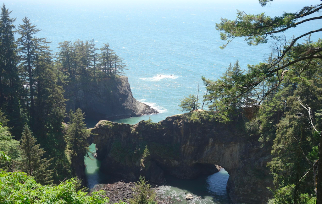
- Samuel H Boardman Scenic Corridor with the famous Natural Bridge
- Harris Beach State Park
- Brookings
FAQ
What is the FKT on the OCT?
The fastest known unsupported time on the Oregon Coast Trail belongs to Lucia Robinson, who finished in 13 days, 00 hours, and 15 minutes in September 2018. She followed the “standard route” as much as possible, but when low tides or unfordable rivers blocked her path, she simply ran around the obstacles. As an unsupported runner, she carried all her own food and gear and paid for food or lodging along the way. She ran a total of 419.3 miles, averaged 32.2 miles per day, and ate 56 candy bars. She keeps an excellent blog, which you can find here.
Is the OCT dog-friendly?
The Oregon Coast is known as the People’s Coast, and that freedom also extends to dogs. Dogs are allowed in State Parks, and on all beaches, but must be on a leash (unless within specific off-leash areas). The only exception is March 15 - September 15, when dogs are prohibited on beaches due to snowy plover regulations. It is expected that dog owners clean up any waste produced by their pets and keeps them calm during quiet hours of 10 pm - 7 am.

How difficult is the Oregon Coast Trail?
The Oregon Coast trail generally ranges from easy to moderate, with elevation gains of no more than a few hundred feet per day (with the exception of Neahkahnie Mountain). While the hiking itself is easy, hikers should train their calves (stairs are a good idea), as hiking many miles through sand each day can be a killer. The other tricky aspect is navigation, as the trail is not very well-marked and the route can often be obscured by tides. Hikers should take care to procure and learn how to read tide tables in advance of their hike.
Should I be worried about trail closures?
Due to the extremely public nature of Oregon’s coasts, closures in the summer are uncommon. Off-season closures due to mud or mudslides are common, as the woody sections of the coast are often along cliffs that can be very dangerous when slippery.
How long is the Pacific Crest Trail in Oregon?
While hiking the Oregon Coast Trail, it is not uncommon to be confused for a PCT hiker (some people don’t realize how much further inland the PCT is). The Oregon section of the PCT is 455 miles of pure beauty, although, unlike the Oregon Coast Trail, it requires permits. Most permits are self-issued and free, although the Central Cascades do require special, limited-entry permits. In especially snowy years, some PCT hikers detour the snow by hopping into the Oregon Coast Trail.

Resources
-
Connie Soper’s book Exploring the Oregon Coast Trail
-
Official maps: while these are good for planning to understand the scope of your adventure, they are not detailed enough to be helpful while on the trail.
-
Bonnie Henderson’s guide book, Day Hiking: Oregon Coast (not an Oregon Coast Trail guide book, but rather a book containing many trails on the Oregon Coast that can be pieced together to do the Oregon Coast Trail)
-
Bonnie Henderson's blog
The photos in this post were taken by Ellen Beahm. All rights reserved.

 650-Calorie Fuel