


Our friend, Kelly Weintraub (@eowynhikes), breaks down her
personal favorite sections, hikes and places from her PCT thru-hike.
I thru-hiked the Pacific Crest Trail in 2017, starting northbound from Campo on May 8. Due to 2017’s record snowfall, an unfortunate stomach bug, and an exceptionally bad summer for wildfires, I didn’t hike straight through from Mexico to Canada. Instead, I was forced to skip around and come back to fill in the sections I missed. Below, in geographical order (south to north), I share my 10 favorite and/or most iconic parts of the trail.
*Related: Pacific Crest Trail Interactive Map.
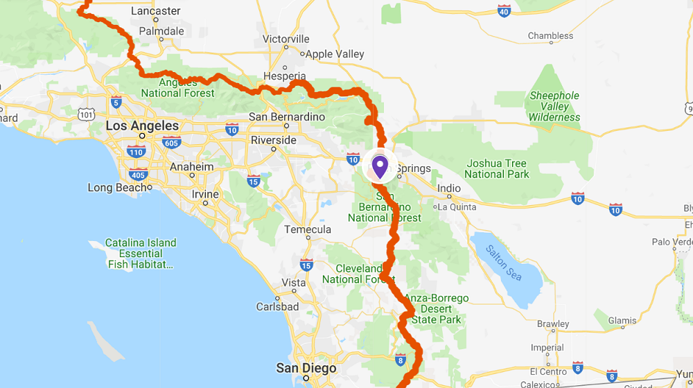
1. MOUNT SAN JACINTO, CA

In retrospect, the long descent from San Jacinto felt like the first of many PCT rites of passage. Iconic? For me, absolutely, though not high on my list of favorites because this stretch was brutal. We spent the night high on the mountain.
The descent took all of the next day - nearly 12 hours of walking downhill. The trail meandered down on an exposed, boulder-covered slope with long views to distant wind farms. Snow-capped San Gorgonio was visible to the north. In the shade, the temperature topped out at 104 degrees. After twelve hours of chasing the trail downhill, we reached The Water Fountain. Yes, there’s a water fountain in the middle of the desert, on the side of a road, courtesy of the local water company.
After the long, dry descent, I was overjoyed to reach it. The fountain is a blessing, but also a source of frustration. That stream of water from the fountain will blow in any direction but into your bottle. Oh, and good luck sleeping through the night. The wind will rip your tent stakes out of the ground but won’t cool things down enough for comfort. But having made it this far, I began to feel like a real thru hiker.
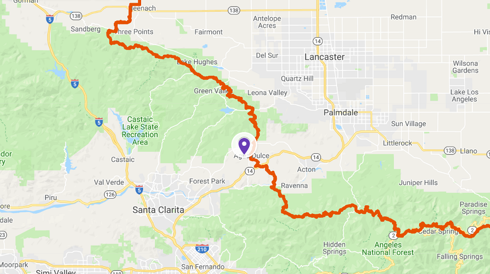
2. HIKER HEAVEN, CA
 credit: wanderlusttravelnurse.com
I met many generous trail angels along the PCT who gifted me with food, rides, and places to stay. I’m singling out Hiker Heaven because, wow. The Saufley’s well-run operation serves hundreds of hikers each year with a personal touch and attention to detail that are unforgettable. It begins with the shuttle, driven by a friendly volunteer, which we met unexpectedly in the parking lot of Agua Dolce’s grocery store. We gratefully accepted a ride to Hiker Heaven.
After a quick tour of the facilities, I used one of the outdoor showers. Afterward, I slipped into loaner clothes and surrendered my filthy clothing for laundering. My resupply boxes had arrived and were easy to locate among the hundreds of others, all impeccably organized by last name.
In the yard, there were plenty of (clean!) outhouses for all. I pitched my tent among cacti and wandering chickens. In the morning, the shuttle returned me to the trail, which runs through Agua Dolce as the shoulder of a main road. Walking the shoulder could have been frustrating, but here it felt like the trail was designed to deliver us to Hiker Heaven for a respite before dumping us back into the desert.
3. MOJAVE DESERT, CA

If you find yourself on this stretch of PCT during a heat wave, like I did, you’ll learn what you’re capable of. From a forested ridge, you make a long descent toward Highway 138. If, like me, you fail to check the elevation profile, you’re in for a terrible surprise when the trail begins to climb just when you thought you’d reached the valley floor. Suddenly you’re going in what feels like the wrong direction. The highway you thought you were hiking toward is now far below. You realize you might not be carrying enough water to get to the highway, after all. There’s no shade. The heat is thick. Despite the wind turbines in the distance, there’s not even a breeze as you struggle across the pale sand.
At last the trail takes you down, and you trudge along a dirt road toward the highway, which stretches away into invisibility. Reach the highway and detour a short distance to Hiker Town. A skeleton greets you at the gate. Collect your resupply box and rest in whatever shade you can find. Load up with water. The next stretch of trail takes you along the California Aqueduct, but all of that water is inaccessible. If you don’t tackle this stretch in the dark, the heat might be unbearable.
In the dark, kangaroo rats race through the light from your headlamp. Red lights on wind turbines blink on and off ahead of you. Eventually you reach those turbines and finally climb out of the desert, through the wind farm, to a creeklet choked with algae. Surviving this stretch is an experience you won’t forget.
4. MATHER PASS, CA

Due to the excessive snowpack, I skipped the High Sierra in July and came back to complete this section in the fall. Thus I approached Mather Pass in late September. I came northbound. The landscape, lush with grass and willow at the South Fork of the Kings River, became suddenly stark. Rock dominated the view. Snow patches lingered. The waxing moon rose over a black mountain to the west. Shadows fell long and deep. As I climbed, small lakes were revealed below me, bright as the blue sky, the only color in view. The landscape looked like a setting for one of Tolkien’s tales, and I felt like the hero of the story, marching toward a great task to be accomplished high on a mountaintop. When I reached the pass, Palisade Lakes appeared to the north, deep in afternoon shadow. Darkness would come quickly. Lows would again drop into the 20s. But I lingered on the pass, in the cold wind, savoring my time at what felt like the top of the world. At the edge of daylight, at the edge of winter, Mather Pass was my favorite part of the entire PCT.
5. MUIR PASS to EVOLUTION LAKE, CA
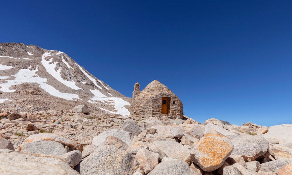
The climb to Muir Pass was eerie. Clouds churned overhead. Late in the season, snow remained banked across the trail. Helen Lake looked sterile and dangerous, like touching it would turn me to ice. Once on the pass, I photographed the iconic stone hut dedicated to John Muir. Clouds to the north were thick and dark and seemed to promise snow. I hurried on.
The trail took me to the shore of Wanda Lake, where the water was turquoise and the mountain backdrop was frosted white with recent snow. The campsite I’d aimed for, near Wanda Lake’s outlet, was already crowded with south-bounding JMTers, so I continued down as quickly as I could, racing nightfall. The sun was already gone, vanished behind ominous clouds. Above Sapphire Lake, I found a flat sandy bench. I quickly set about pitching my tent. As I shoved in the last stakes, the mountains around me lit up with alpenglow so spectacular the whole basin glowed pink. The photographs I took then are my favorite of the entire hike.
Early the next morning, I made my way down Evolution Basin. I saw no other hikers. The frozen ground crunched under my shoes. The lakes were edged in ice. Sunlight lit the tallest peaks and oozed downward, gifting me phenomenal photographs. I would have lingered long in this beautiful place if I wasn’t racing winter through the High Sierra.

6. MOUNT THIELSON, OR

This gem was completely unexpected; Mount Thielsen is rarely included in PCT guides and hiker blogs as one of the trail’s highlights. I didn’t see much of Thielsen during my approach from the Crater Lake Rim Trail because the mountain was obscured by wildlife smoke and an intense thunderstorm. Thus the mountain snuck up on me. When I finally got my first clear view of Thielsen, I was already on its flanks. It was love at first sight. I laughed with joy when I saw the peak, because the mountain looked like an illustration out of a fairytale.
I stopped for lunch on Thielsen’s shoulder, where the peak presented an entirely different profile. After lunch I traversed Thielsen’s hemlock forests as yet another thunderstorm moved in. At Thielsen Creek, I stopped for water and admired the ever-changing view of the mountain. I suffered pangs of sadness when the triangular summit finally dropped out of sight, for Theilsen had seduced me with its many splendid faces.
7. LAVA FIELDS of McKENZIE PASS, OR

Between Three Sisters and Mount Washington the trail meanders through lava fields. Treading through thick fog on a path of seemingly endless rock, I felt like I’d been transported to another world. For awhile it was just me and the rocks and the mist. Then the fog began to lift, and to the south Three Sisters rose above the mist. Mount Washington appeared as I crested a knoll.
The mountain’s angular beauty surprised and dazzled me. Here was another pointed peak whose praises I hadn’t seen sung, but who I instantly came to love. Mount Jefferson rose behind Washington, snow-covered and shimmering. I loved the lava fields. I even loved the tough, rocky footing, which made this stretch so otherworldly. Had I gone through on a scorching afternoon, rather than a foggy morning, I might feel differently about the lava fields. But I doubt it. Stark, spectacular landscapes rarely fail to capture my heart, especially when a pointy peak is involved. With Three Sisters on the horizon and Mount Washington rising from the mist like an ethereal Mount Doom, my heart didn’t stand a chance.

8. THREE FINGERED JACK, OR

I crossed the highway at Santiam Pass and climbed toward Three Fingered Jack through the blackened remains of trees that burned in a previous year. As sunset approached, I found a campsite high on the slope with a view of Three Sisters and Mount Washington. The next morning, I drew closer and closer to Three Fingered Jack’s jagged summit. The trail took me on a scenic traverse beneath the summit on the south side. I made terrible time because I kept stopping to photograph the scene. Eventually I crested a ridge and faced a wonderful view of Mount Jefferson (and the fires burning on its slopes). I crested the next shoulder and looking for another view of Jack’s summit. Wow! It was right beside me, seemingly close enough to kiss. From this side, the peak was a jagged formation of black rock shot through with red zig zags — unlike anything else on the trail, and totally beguiling.
Just north of Three Fingered Jack, the PCT was closed due to wildfire. Because the alternate involved 34 miles of highway-walking, the popular choice was to get a ride around the closure from a team of generous trail angels who offered daily rides from Big Lake Youth Camp to Olallie Lake. Hikers who took this option bypassed the magic of Three Fingered Jack. I’m thankful I opted for the alternate. My intimate encounter with this mountain was worth two days of road-walking.

9. GOAT ROCKS WILDERNESS, WA

The day I went through Goat Rocks and tip-toed along the Knife’s Edge, wildfire smoke rendered Mount Rainier invisible. Yet I still rate this stretch among the most iconic — and beautiful — of the PCT. Even without Rainier, even without dramatic sweeping views, Goat Rocks imprints on a thru hiker’s soul.
In late August, mountainsides of pasque flower puff-balls greet the hiker on the descent from Cispus Pass. Even when the distant views are smoked over, these seed puffs elicit a smile. Soon you’ll have to make a choice: the official PCT, which may include traversing two sketchy snowbanks, or the steep scenic route with its Knife’s Edge and access to Old Snowy. The Knife’s Edge is the PCT’s best imitation of a roller coaster. The drop-offs on either side roil the stomach. The footing is loose and precarious. On a clear day, the views are apparently endless. My views ended a half mile or so from my feet. No Rainier, but spectacular nonetheless. I don’t know where the Knife’s Edge officially ends.
For miles, the PCT balances along a narrow ridge. The views back to Old Snowy were the best views of the day: snow-covered and dramatic, split by the thin thread of trail I’d just come down. On a clear day, the beauty of Goat Rocks surely rivals the High Sierra.
10. ALPINE LAKE WILDERNESS, WA

I entered Alpine Lakes Wilderness on one of those rare days when the wind shifted and all of the wildfire smoke cleared out. Mountains went on for miles. Lake after lake appeared below the trail. To the south, I could finally see Mount Rainier – along with two tall plumes of smoke from the Norse Peak Fire. I’d skipped the High Sierra, and Goat Rocks was smothered by smoke from these fires, so Alpine Lakes Wilderness was the first truly spectacular scenery of my hike. I practically pranced up the trail, in love with the world as I soaked up the ever-changing views of Mount Rainier and Joe Lake.
My second day in Alpine Lakes Wilderness, I woke to find that the wind had again shifted. Visibility dropped to less than half a mile due to smoke from yet another wildfire. As I walked, visibility dropped still more, until I couldn’t see beyond the trees in front of me. But in this haze, I had the best wildlife encounter of my hike when I came upon a pine marten clinging to the side of a hemlock tree. This was the third marten I’d seen during my hike, but the first that didn’t bolt the instant it saw me. We checked each other out for several minutes, long enough for me to pull out my camera and capture the encounter on video.
Alpine Lakes Wilderness further endeared itself to me that night, when a pika dashed through my campsite with a mouthful of flowers. The next morning, I saw a bear foraging for berries. With spectacular views and abundant wildlife, Alpine Lakes Wilderness was the highlight of my time in smoke-choked Washington.
 650-Calorie Fuel