


A “14er” is a mountain that towers over 14,000 ft. There are 58 of these giants in Colorado alone, and tackling one is an exhilarating experience offering breathtaking views and some serious hiking cred.
But even for the most conditioned hikers, it’s no easy task. In this post, we’re covering everything to know about these 58 majestic mountains and we’re listing tips on how to hike one, or even all of them if you so choose (a bucket list item for many outdoor adventurers.)
Let’s get to it.
To Print PDF: Step 1) Expand to full screen view (click box in top right hand corner of map). Step 2) Zoom in to your desired map section view. Step 3) Click on the three white vertical dots and then "Print Map" from that drop down menu.
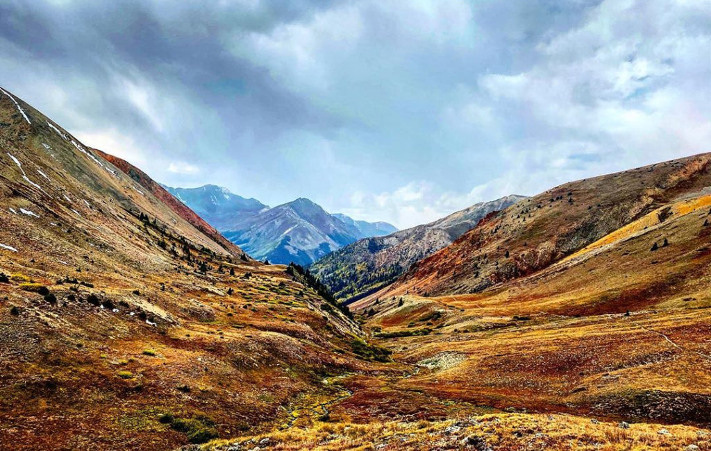
ELK MOUNTAINS
 © John Fowler (CC BY 2.0)
Known for epic views, jagged peaks, and sharp valleys, these mountains are no strangers to class four climbs and plenty of snowfall. The Elk Mountains are home to 7 fourteeners, the easiest of which is Castle Peak.
| Name | Elevation | Class | Description |
|---|---|---|---|
| Capitol Peak | 14,130 ft | Class 4 | A stunning, grand mountain found in the Maroon Bells-Snowmass Wilderness; this sharp-edged peak is said to be the most difficult 14er. It has one of the tallest northern mountain walls in Colorado. |
| Castle Peak | 14,265 ft | Difficult Class 2 | Found near Aspen, this is the tallest summit in the Maroon Bells-Snowmass Wilderness and the Elk Mountains. It's said to be the "easiest" 14er in the Elk Range. |
| Conundrum Peak | 14,060 ft | Difficult Class 2 | Another debatable 14er because of its saddle, this peak is near Aspen and it features loose rock, snow, and ice most of the year. |
| Maroon Peak | 14,156 ft | Class 3 | Maroon Peak connects to nearby North Maroon Peak, together called The Maroon Bells. Maroon Peak is the main point, and this set is known for its brilliant colors each Fall. |
| North Maroon Peak | 14,014 ft | Class 4 | The sister mountain to South Maroon Peak, these 2 mountains are one of the most photographed in the U.S. The trek is more climbing than hiking and is said to hold Colorado's most difficult crux. |
| Pyramid Peak | 14,018 ft | Class 4 | 13 miles outside of Aspen, this technical mountain is made from sedimentary loose rugged rock. A helmet is required to scale its last 1,000 ft. |
| Snowmass Mountain | 14,092 ft | Class 3 | This remote peak is the fourth highest in the Elk Mountains. It features a snow-field on its eastern face—one of Colorado's largest. The mountain can't be seen from roads. |
FRONT RANGE
 © James Tiffin Jr. (CC BY-SA 2.0)
This is the second-largest mountain range, and it’s called the “Eastern Gateway to the Rockies.” It's home to popular Colorado towns including Boulder, Colorado Springs, Denver, and Fort Collins. It count 6 peaks above 14,000 feet.
| Name | Elevation | Class | Description |
|---|---|---|---|
| Grays Peak | 14,270 ft | Class 1 | The tallest point in the Front Range and the Continental Divide, this mountain peak is easily spotted from the Great Plains. |
| Longs Peak | 14,255 ft | Class 3 | Known as one of the hardest yet most popular 14ers, Longs Peak is 90 minutes outside of Denver. The climb is difficult, requiring endurance and experienced scrambling and mountaineering skills. |
| Mt. Bierstadt | 14,060 ft | Class 2 | Lying in the Mount Evans Wilderness of Pike National Forest, this moderately rated peak is more accessible than other 14ers with its well-maintained trail and close vicinity to Denver. |
| Mt. Evans | 14,264 ft | Class 2 | This peak can be spotted from miles away, as it sits along the Rockies Eastern edge. There's a 14-mile scenic drive that leads directly to its summit. The drive up boasts plenty of wildlife and outstanding views for all ages. |
| Pikes Peak | 14,110 ft | Class 1 | Like Mt. Evans, there is a road to this mountain peak. As for hiking, the climb is long and steep, filled with difficult terrain. |
| Torreys Peak | 14,267 ft | Class 2 | This mountain is near Denver and neighboring Grays Peak. It is the only 14er on the Continental Divide. |
MOSQUITO RANGE
 © Matt Vincent (CC BY-SA 3.0)
Found in central Colorado, this range stretches about 40 miles north to south. The 14ers in the area are easier and often fairly crowded.
| Name | Elevation | Class | Description |
|---|---|---|---|
| Mt. Bross | 14,172 ft | Class 2 | Located in Pike National Forest, this hike is popular among hikers looking to complete 3 hikes in one day since it shares a trailhead with Mt. Democrat and Mt. Lincoln. It's the easiest climb out of the 3. |
| Mt. Cameron | 14,238 ft | Class 2 | Also known as "Cameron Point," this mountain lies in the DeCaliBron Loop (which includes Mt. Cameron, Lincoln, Bross, and Democrat). Cameron's 14er title is debated as the mountains saddle doesn't meet the 300 ft rule. |
| Mt. Democrat | 14,148 ft | Class 2 | Leading the way as the first mountain in the DeCaliBron Loop, the climb to the summit is short and steep, granting 360-degree views of fellow 14ers. |
| Mt. Lincoln | 14,286 ft | Class 2 | This towering peak is the highest in the Mosquito Range and Park County, and the mountain was given its name in honor of President Lincoln. |
| Mt. Sherman | 14,036 ft | Class 2 | This peak easily blends into its neighboring ones. There are 2 routes to its summit, both featuring gentle ridgelines that make for a kinder climb. |
SANGRE DE CRISTO MOUNTAINS
 ©
© Located in southern Colorado, this stretch of mountains is home to deep valleys and most of the class 3 14ers with sharp, steep peaks. The mountain ranges geography causes frequent unpredictable weather. The Sangre de Cristo mountain range hosts a total of 10 peaks over 14,000 feet.
| Name | Elevation | Class | Description |
|---|---|---|---|
| Blanca Peak | 14,345 ft | Difficult Class 2 | Recommended for only highly skilled hikers, Mt. Blanca is a challenging climb to the highest peak in the Sangre de Cristo and Sierra Blanca Massif Mountains. |
| Challenger Point | 14,081 ft | Difficult Class 2 | Lying in front and to the west of Kit Carson Peak, the trail to the top of this high-rising peak includes a waterfall, lake, and awesome views. It was named for the crew of the Space Shuttle Challenger of 1986. |
| Crestone Needle | 14,197 ft | Class 3 | Labeled as one of the top 5 toughest and most rugged, this peak was one of the last 14ers to get climbed. The route is difficult to navigate and there are sections where class 3 technical climbing is required. |
| Crestone Peak | 14,294 ft | Class 3 | Often called "The Peak," this remote mountain is the second highest summit in the Sangre de Cristo Range. It has two summits, with the western one being 34 ft. higher. |
| Culebra Peak | 14,047 ft | Class 2 | This is the most historic 14er (dating back to the late 1600s) and the highest peak in the Culebra Range. It is also the only privately owned 14er. |
| Ellingwood Point | 14,042 ft | Difficult Class 2 | Named after one of Colorado's most famous climbers, Albert Ellingwood, this hike includes long exposure areas and a lake. The trail gets tricky, so best keep a detailed map at hand. |
| Humboldt Peak | 14,064 ft | Class 2 | This is one of the easier 14ers to hike in the area. There are views of Needle, Crestone Peak, and the Wet Valley on the way up. |
| Kit Carson Peak | 14,165 ft | Easy Class 3 | The fourth tallest point in the Sangre de Cristo Range, this peak has several sub-summits. |
| Little Bear Peak | 14,037 ft | Class 4 | One of the toughest and most dangerous 14ers to scale, this monster stretches 6,000 ft. above the rest of the San Luis Valley. Climbers—beware of loose falling rock. |
| Mt. Lindsey | 14,042 ft | Easy Class 3 | Most of the mountain is moderately easy to climb until you reach the ridge scramble that gets technical. Gear and helmet required. |
SAN JUAN MOUNTAINS
 ©
© The San Juan’s include 7 unique wilderness areas stretching into northern New Mexico. The area is home to rich minerals and mining towns and a variety of class 1-4 mountains for hikers and climbers alike. The San Juan Mountains host 14 fourteeners as well as Colorado’s largest Western Slope.
| Name | Elevation | Class | Description |
|---|---|---|---|
| El Diente Peak | 14,159 ft | Class 3 | Known as one of the toughest climbs over dangerous terrain, the English translation for its name is "the teeth" because of its dramatic peak. |
| Handies Peak | 14,048 ft | Class 1 | To reach this summit, you'll first wander through the American Basin and then complete a steady climb to views of the Grenadier Range, the La Garita Mountains, the Needle Mountains, and the Mt. Sneffel Wilderness area. |
| Mt. Eolus | 14,083 ft | Class 3 | This mountain has 2 summits with the southern point as the larger. It's in the Needle Mountains and was named after the Greek God of the winds. |
| Mt. Sneffels | 14,150 ft | Easy Class 3 | The highest point in the Sneffels Range, this beautiful mountain is referred to as the "Queen of the San Juan's." It's found in commercial photography everywhere and has been a backdrop in movies. |
| Mt. Wilson | 14,246 ft | Class 4 | Found in the Lizard Head Wilderness, this challenging mountain is one of the western-most peaks and the highest in the San Miguel Mountain Range. It's close to two other 14ers located outside Telluride. |
| North Eolus | 14,039 ft | Class 3 | This less famous peak lies just 15 minutes away from its more popular neighbor Mount Eolus. The summit is worth the climb offering sights of several surrounding peaks. |
| Redcloud Peak | 14,034 ft | Class 2 | Named after the visible red coloring of its peak, this picturesque mountain is often hiked alongside Sunshine peak. |
| San Luis Peak | 14,014 ft | Class 1 | The highest point in the La Garita Mountains, this remote and often desolate peak is tricky to reach as it sits 2 hours from any paved roads. |
| Sunlight Peak | 14,059 ft | Class 4 | A lofty peak tucked in the Chicago Basin in the Needle Mountains, there's an extensive amount of exposure, scrambling and a summit block on the way to its top. |
| Sunshine Peak | 14,001 ft | Class 2 | A neighbor to Redcloud peak, the two are often hiked as a set. Like Redcloud, Sunshine has red rocks at its summit and mixed terrain of trail and scree. |
| Uncompahgre Peak | 14,309 ft | Class 2 | This peak is the highest point in the San Juan Mountain Range and Colorado's largest Western Slope. It is one of the easier 14ers in its area. |
| Wetterhorn Peak | 14,015 ft | Class 3 | A beloved 14er that's great for hikers trying their hand at scree and scrambling, this rock-faced mountain can be found just outside of Lake City. |
| Wilson Peak | 14,017 ft | Class 3 | This gorgeous rocky mountain is the highest peak in San Miguel County, and it's the face of all Coors products! |
| Windom Peak | 14,087 ft | Difficult Class 2 | This popular hiking destination is in the remote subrange Needle Mountains found in the Weminuche Wilderness area. The hike to the summit will take multiple days, but there is no technical gear required. |
SAWATCH RANGE
 ©
© This range stretches 100 miles north-south along the Colorado Continental Divide. It contains the most peaks above 13,800 ft. out of all the Colorado Ranges. It also includes 8 closely knit 14ers called the Collegiate Peaks, which are each named after famous U.S. Ivy League Universities. The peaks include Mt. Belford, Mt. Columbia, Mt. Harvard, Huron Peak, Mt. Missouri, La Plata Peak, Mt. Oxford, and Mt. Yale.
| Name | Elevation | Class | Description |
|---|---|---|---|
| Huron Peak | 14,003 ft | Class 2 | Located along the western side of the Sawatch Range, this trail is a moderately steady hike with a more rugged climb to its summit. |
| La Plata Peak | 14,336 ft | Class 2 | Found in the Collegiate Peaks Wilderness in the San Isabel National forest, you can spot this mountain by its rocky summit and wide-spreading western flank. |
| Missouri Mountain | 14,067 ft | Class 2 | Also in the Collegiate Peaks Wilderness, this mountain is popular for beginners and families with a summit granting some of the best views around. |
| Mt. Antero | 14,269 ft | Class 2 | The highest mountain out of the southern Sawatch Range, it's located in the San Isabel National Forest. There are several moderately rated hiking routes on the mountain. |
| Mt. Belford | 14,197 ft | Class 2 | This beautiful mountain sits close to Mt. Oxford and Mt. Missouri. Its location and extravagant views make it a favorite among the 14ers. |
| Mt. Columbia | 14,073 ft | Class 2 | This Collegiate Peak overlooks the Arkansas River Valley and several fellow collegiate peaks. It's unpopular among hikers because of its battered, steep, and slippery trail. |
| Mt. Elbert | 14,433 ft | Class 1 | This is the highest peak in Colorado and the Rocky Mountains and the second-highest in the lower 48. The climb to the summit is reasonably moderate and suitable for a variety of skill levels. |
| Mt. Harvard | 14,420 ft | Class 2 | The highest summit of the Collegiate Peaks and the fourth highest peak in the contiguous U.S., the climb begins gradually and steepens the closer you get to the summit. |
| Mt. Massive | 14,421 ft | Class 2 | The hike to this peak is difficult but not technical, although it's best suited for experienced hikers. This is the second-highest peak in the Rockies and it has five summits along 3 miles that reach above 14,000 ft. |
| Mt. of the Holy Cross | 14,005 ft | Class 2 | The most northern mountain in the Sawatch, its northeastern side is often covered in snow that creates a crucifix design (hence the name given by Herbert Hoover.) |
| Mt. Oxford | 14,153 ft | Class 2 | This mountain is only 1.5 miles from Mt. Belford, and the two are often hiked as a set. The climb to its peak isn't technical, although it's steep with a long-exposed ridgeline. |
| Mt. Princeton | 14,197 ft | Class 2 | Located in the San Isabel National Forest, this peak grants breathtaking views of both the Arkansas Valley and the rest of the Sawatch Range. The hike requires no technical skills. |
| Mt. Shavano | 14,229 ft | Class 2 | Named after a Tabeguache Ute tribe chief, this mountain is in the southeastern part of the Sawatch Range inside the San Isabel National Forest. It has deep valleys along its eastern face, and when filled with snow they resemble an angel with outstretched wings—referred to as the "Angel of Shavano." |
| Mt. Yale | 14,196 ft | Class 2 | The eighth tallest peak in the Sawatch Range, it is one of the only 14ers in the area that has a paved road leading to the trailhead. |
| Tabeguache Peak | 14,155 ft | Class 2 | Shadowed in the southern portion of the Sawatch, this less popular 14er sits right beside the more prominent Mt. Shavano. You used to have to climb over Tabeguache to reach Mt. Shavano, but this has reversed due to erosion concerns on the previous trail. |
TENMILE RANGE
 © M M (CC BY-SA 2.0)
Just west of Breckenridge, this small range is named after its 10 peaks that stretch from Central Colorado and end at the Continental Divide. The area is a popular ski destination as it includes over 5 ski resorts. The Tenmile Range only has one 14er.
| Name | Elevation | Class | Description |
|---|---|---|---|
| Quandary Peak | 14,265 ft | Class 1 | The highest summit of the Tenmile Range in the Rocky Mountains, this is one of the most climbed 14ers. |
Q&A
How many 14ers are there in Colorado?
The exact number of 14ers in Colorado is debatable since some only consider a mountain a 14er if it has at least 300 feet of prominence from its topographic saddle. We’ll leave that up to you to decide, but for our list, we’re rolling with the 58 peaks the Colorado Geological Survey claims to be over 14,000 ft.
How are the summits categorized?
Hikes are divided into three categories:
- Easy: Clearly-marked trail with a gradual ascent.
- Moderate: Greater elevation per mile, may include some scrambling.
- Strenuous: Long, steep hike with obstacles (boulders, rocks, roots, etc.)
In addition, mountains like 14ers have a difficulty rating—or “class rating”—of 1-5 based on the Yosemite Decimal System:
- Class 1: Moderately easy, low risk.
- Class 2: Moderately difficult, map-reading skills required, may include loose rock, steep summits, snow.
- Class 3: Difficult ascent, scrambling and/or climbing sections, technical gear suggested, steep terrain, boulders, snow.
- Class 4: Tactical climbing with ropes, dangerous terrain, high exposure, more climbing than hiking.
- Class 5: Expert-level, extensive, technical free-climbing (need climbing shoes, rope, harness, all the gear!)*
* Class 5 hikes may also include decimals or letters after them (5.1, 5.1a) for further climbing details. None of the 14ers are rated as a class 5, although sections of the most strenuous trails come close.
What is the easiest 14er to hike in Colorado?
Mount Bierstadt (14,060 ft.) is known as one of the easiest 14ers. It’s rated as a Class 2 with a long and gradual ascent to its summit. The hike is suitable for many skill levels, and because of its friendly nature, it’s also one of the most highly trafficked mountains.
What is the hardest 14er in Colorado?
Capitol Peak (14,131 ft.) is more a climb than a hike. It’s technical, dangerous, and ends with scaling a section called the “Knife Edge” that has 1,000 ft. drops on each side. This strenuous climb is best left to the experts, as there’s plenty of scrambling rock faces and climbing involved. Campsites are located near Capitol Lake as the hike averages a minimum of two days to complete.
When should I worry about altitude sickness?
Symptoms of mild altitude sickness include fast breathing, headaches and nausea. More severe cases can lead to your brain swelling and even fluid to be released in your lungs. Needless to say, it's a serious condition that you should be prepared for. Note that elevation effects can hit at night, even if a person seems okay throughout the day.
To prevent altitude sickness, a good rule of thumb is to climb no more than 1,000 feet per day above 8,000 feet. This will allow your body to acclimate and keep you from getting sick. Take your time and pay attention to early signs of altitude sickness.
If you or your partners experience any symptoms, go down to a lower elevation and stay there until the symptoms go away. Give your body the time to acclimate before you continue. If your symptoms are severe, get back to 4,000 feet of elevation or below as soon as you can, and seek immediate medical attention.
Beginner Tips
Training:
- Condition beforehand: cardio, weights, endurance, flexibility, all that good stuff.
- Work your way up: attempt hikes that average 4-8 hours first, and a few 13ers.
- Try to hike between June-September.
- Check ahead of time for rules/permit requirements.
- If you’re not local to Colorado, it’s best to spend a few days ahead of your hike getting acclimated to the elevation change.
The Hike:
- Hydrate and fuel up.
- Check the forecast.
- Choose a 14er that matches your skills.
- Research the trail ahead of time and bring the necessary equipment.
- Start early! As early as you can, those afternoon storms are unpredictable.
- Wear sunglasses, they help with headaches.
- Wear sunblock, even on cloudy days.
- Pace yourself, stay hydrated, have fun!
Packing List:
- First Aid Kit
- Hat
- Sunscreen
- Sunglasses
- Rain gear
- Warm clothes for the top (gloves, hat, jacket, pants)
- Ziplock bag & TP (it’s a long climb)
- Headlamp
- Water
- Snacks
- A portable phone charger, if you’re into that
- Matches
- Knife/Multi-tool
- Trail map/Compass/Top Map
For more gear items check out this 8.5 lbs Ultralight Backpacking Gear List

 650-Calorie Fuel