


Trail Overview
Start and end points: Talimena State Park and Pinnacle Mountain State Park
Best time to hike: Spring and Fall
Length: 223 miles
Highest elevation: 2,600 ft
Total ascent: 34,340 ft
Total descent: 34,914 ft
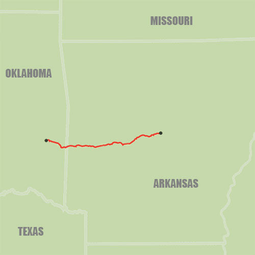
The Ouachita (pronounced waa-shee-tuh) National Recreation Trail aka the “Ouachita Trail” or “OT” spans 223 miles through the Ouachita National Forest and mountains of Oklahoma and Arkansas.
The trail is typically hiked West to East starting in Talimena State Park in Talihina, Oklahoma, and ending at Pinnacle Mountain State Park near Little Rock, Arkansas. The OT also boasts over twenty well-maintained shelters and numerous campground and tent sites.
It is open to hikers, backpackers, hunters, and mountain bikers from miles 0 to 30.5 and 54 to 160. No permits or registrations are required to hike any part of the OT.
The Ouachita Trail is almost entirely covered by trees with fleeting views of the rolling Ouachita mountains. The western part of the trail is very rocky with lots of overgrowth making the hiking difficult with some days seeing switchbacks and 3,500 ft+ of gain.
Expect tall pine and oak trees throughout, as well as green ferns and moss in some spots. The eastern portion of the trail is flat with almost no elevation gain for the last 30 miles.
This is a perfect trail for first time thru-hikers.
Doggos are welcome on the OT, but they should be leashed or under voice control. Rocks, briars, ticks, and wild animals can all be a danger to pets. Please make sure your dog is trail-ready.

Planning Your Thru-Hike
Getting there: Access and Transportation
The western terminus of the trail is in Talimena State Park in Talihina, Oklahoma. It is a 2 and a half hour drive from Tulsa International Airport in Tulsa, Oklahoma.
The eastern terminus is in Pinnacle Mountain State Park, a 25-minute drive from Little Rock, Arkansas.
Ouachita Trail Guide’s Mike and Lynn (918-383-0060) offer a shuttle along the entire trail, including pickups at airports and bus stations. Lori at the Bluebell Cafe (870-867-3999) also offers a shuttle service on the Arkansas side.
The Facebook “Friends of the Ouachita” group is another great resource for those seeking rides.
When to Go: Timing, Weather and Seasons
Prime times to hike the OT are mid-September to early November and March to April. The leaves are changing color or just blooming, the insects are fewer, and this is when most trail maintainers are out clearing away the summer growth or winter storm damages.
Always be prepared for quick changes in the weather though as both seasons can see frost and thunderstorms.
After April the temperature can get too hot, mosquitos are out in full swarm, and finding water can become a challenge.
Where to Sleep: Camping, Shelters, and Hostels
The OT has a shelter system comprised of 21 “AT style” three-sided shelters located every 8-12 miles. For a detailed list of shelters and their mile markers, visit friendsoftheouachita.org
One thing to note is that not all shelters are near a dependable water source and none of them have privy or pit toilets. You will typically find a shelter log and some may come stocked with brooms and tarps.

Moonshine Shelter, mile 158.4
If sleeping in a shelter is not your thing, or you find them full, there are numerous campgrounds and tent sites along the trail. Camping is allowed along most of the trail with the exception of the last 20 miles in the east. Stealth camping is also permitted except for within the state parks or from mile 194 going eastbound.
Developed campgrounds include:
-
Winding Stair Campground (mile 23.8) is a Ouachita National Forest fee campground. The campground has 23 tent sites, parking, vault toilets, and showers (single sites $8/night). It also has several backpacker’s campsites, with picnic tables, bear poles, and pit toilets slightly separated from the main campsite ($3/night). The developed campground closes during the winter, the exact dates change, but the backpacker sites remain open (with no fees if the main campground is closed).
-
Queen Wilhelmina SP (mile 51.5) The park includes 41 campsites (eight Class A, 27 Class B, five tent sites with water, and one hike-in tent site) less than 0.5-mile west of the Queen Wilhelmina Lodge aka the “Castle in the Clouds”. The advantages of staying here are the modern bathhouse and access to the Lodge with its AYCE buffet and lobby with TVs and charging outlets. Water is shut off at campsites and the day-use bathroom is closed beginning December 1 for the winter. The current cost is $14 per night.
-
Big Brushy Recreation Area (mile 94.5) is the location of an old campground that is now a day-use site. There is a pit toilet and covered pavilion at the site for a nice place to rest or eat during the day. A couple of trash cans are on site as well.
-
Lake Sylvia Recreation Area (mile 187.3) has another Ouachita National Forest fee campground 0.4 miles north the OT. The campground has water and a nice bathhouse with hot showers. Open typically from April to late October. No reservations.
How to Resupply: Water and Food
1. WATER
Depending on rainfall, water can be a major concern for hikers. Heavy rainstorms can often lead to flash flooding, making river crossings impassable, and droughts can often lead to long dry stretches. For the most part, hikers can count on encountering a water source every 5-10 miles along the trail. However, there are typically two sections that hikers should prepare for:
-
From Talimena State Park (mile 0) to Big Cedar Creek (mile 29.9): Bohannon Creek (mile 7.2) and Horsethief Springs (mile 19.9) are generally reliable but can dry up. If they do, hikers have a 30-mile dry stretch. Fortunately, there are several good places to cache water along the route: Deadman Gap, Holson Valley shelter, and the Winding Stair trailhead.
-
From Foran Gap (mile 67.7) to Big Brushy (mile 94.5): Only Tan-a-Hill Spring (mile 74.2) is considered reliable, but it is a low flow spring that is 0.3 miles off the OT. Sometimes water can be found near the Turner Gap shelter (mile 79.8) downhill from the shelter in the creek bed. The best place to cache water for this stretch is along Forest Service Road 76.
It is recommended that all water be treated or filtered.

Bluebell Cafe biscuits and homemade gravy
It is fairly common for hikers to place resupply or water caches along the OT. Trail angels also frequently fill water caches and leave coolers with refreshments in various locations, though this should not be depended on.
If you do prepare a cache, please ensure that your cache is waterproof, labeled with your name and expected pickup date, and is carefully packaged to prevent odors from attracting animals. Of course, you always take a risk of someone or something getting to your cache before you.
If you opt not to resupply via cache, there are a handful of excellent resupply locations:
-
Queen Wilhelmina Lodge (mile 51) in Mena, Arkansas will hold packages for you. They are also a great place to stop due to their AYCE buffet and hot showers
-
Bluebell Cafe and Country Store (mile 121) in Story, Arkansas was recently named one of the 20 Best Restaurants on America's Long Distance Hiking Trails and I can personally attest to this. Not only was the homemade food superior but Lori knows the trail backwards and forwards and goes out of her way to help hikers. There is also a motel nearby if you end up in a food coma like I did.
-
Mount Ida, Arkansas is 18 miles south of the OT trailhead on Hwy 27. They have a few motels, cabins, a laundromat, Dollar General, and several restaurants if you’re feeling like a zero-day is needed.
River Crossings
Plan for your fair share of daily river and creek crossings.
The majority of the river and creek crossings on the OT are perfectly safe. Some bigger rivers have bridges and other smaller creeks can typically be forded without any issue.
However, during periods of heavy rain, some rivers and creeks can become dangerous to cross, even on low water crossings or bridges. Use good judgment and wait if the water is too high or the current is too strong. Generally, the creeks will subside within several hours or a day.
You might also consider bringing sandals to make fording easier and to keep your shoes dry.

Irons Fork Creek
Navigation: Maps and Apps
The OT is generally well-marked with blue blazes and trail markers. The mile markers are laid out from west to east (Oklahoma to Arkansas) and this also tends to be the more popular direction to hike.
Despite the multitude of markers and signage the trail is overgrown in many places and, when covered with fall foliage, can render the trail difficult to find. So, it’s important to always have a map.
Guthook Guides (iOS & Android) or Arkansas Hiker (Android only) are two of the most popular hiking apps for the OT. The Guthook and Arkansas Hiker apps are usually accurate, up to date, and include waypoints for shelters, trailheads, trail junctions, and water sources.
Note that varies along the trail but Verizon seems to have the best coverage.
The Ouachita Trail Guide by Tim Ernst is another great resource for navigation. Ernst’s website offers the guide as well as waterproof topographic trail maps of the OT. Ernst has divided the OT into 10 sections in his guide, and those sections are used by Friends of the Ouachita Trail (FOOT) and many other organizations when referencing the OT.

A blaze and trail marker
Sights: Nature and Wildlife
The OT is a breeding ground for spiders, walking sticks, ticks, and other insects. Insect repellent should definitely be included in your packing list.
Salamanders, foxes, snakes, raccoons, and bobcats also call the OT home. Feral hogs and bears have also been sighted on occasion.
Bear canisters are not required at this time but you may consider bringing an Ursack to prevent critters from stealing your food at night.
There are numerous hunting seasons for deer, bear, and other animals in both Oklahoma and Arkansas, with the dates changing each year. Basically, almost all the fall is a hunting season and it is legal to hunt some common animals all year.
There are no restrictions about hunting near the trail, so you may see hunters and hear gunshots near or even on the OT. Therefore, it is highly recommended that all hikers, and their dogs, wear bright orange clothing during the fall and winter.

Wearing orange is encouraged during hunting season
Resources
-
OuachitaMaps.com (weatherproof topographic maps)

 650-Calorie Fuel