


To Print PDF: Step 1) Expand to full screen view (click box in top right hand corner of map). Step 2) Zoom in to your desired map section view. Step 3) Click on the three white vertical dots and then "Print Map" from that drop down menu.
Overview

Length: 273 miles
Time to hike: 2 to 4 weeks
Start and End Point: The Southern terminus is Williamston, MA. The Northern terminus is Journey's End road in North Troy.
Highest elevation : Mount Mansfield (4,394 ft)
Lowest elevation : Winooski River at Jonesville (326 ft)
Opened in 1930, the Long Trail in Vermont is the oldest long-distance hiking trail in the United States and reportedly inspired Benton MacKaye to plan the Appalachian Trail. It spans the length of Vermont traversing the Green Mountains' significant summits.
 © dvs (CC BY 2.0)
Planning Your Thru-Hike
When to go: Timing, Weather and Seasons
Although the hiking season for the Long Trail starts in June and ends in October, we think the ideal time to go is in September. This is when crowds diminish, bugs nearly vanish, temperatures are moderate and the autumn leaves come out.
In case you decided to start hiking earlier in the Summer or later, in October, here are some of the disturbances you are likely to encounter:
1. Crowds: In 2018, 200,000 hikers walked the Long Trail, mostly day and section hikers. The Long Trail also gets some traffic from the Appalachian Trail, which overlaps the LT's southernmost 100 miles. The crowds considerably diminish once the AT turns towards NH and Maine.
2. Mud/Snow: There is a good reason why Vermont is known as "Vermud". Snow can start covering the trail as early as October, and will usually persist all the way through March. When the snow finally melts, the trails get covered in deep mud, sometimes as high as knee level. The Green Mountain Club, which supervises and maintains the trail, discourages any hiking prior to Memorial Day Weekend.
3. Bugs: The Long Trail attracts lots of bugs following mud season, mosquitoes and blackflies being the most dreaded ones. They will fly into your eyes, buzz your ears and you may even swallow a few while hiking.

Getting There: Transportation
To/From the Southern Terminus: The southern terminus is located in Williamstown, MA and there are many bus lines traveling to and from Williamstown that you can choose from.
The most common option is to fly into New York and catch the Peter Pan Bus Line from Port Authority directly to Williamstown and vice verse if you're starting up north. But if New York is out of your way, Peter Pan can also take you to and from the trailhead from Massachusetts or Connecticut.
To/From the Northern Terminus: The airport nearest to the north end of the trail is located in Burlington, VT. From Burlington, it is a 90-minute drive to get to the trailhead in North Troy.
Unfortunately, there are no direct bus lines connecting the trail on this side of the state; your options to get to and from North Troy are to either hike, grab a cab or hire a private shuttle.

Direction to Hike: Northbound or Southbound?
The most popular and easiest way to hike the LT is northbound.
The first 104 miles of the Long Trail (South) are shared with the AT and are not as difficult as the remaining 170 miles. Thus, starting at the southern terminus allows you to get in gear before hitting the rugged and remote terrain in the North.
 © Famartin (CC BY-SA 4.0)
Navigation: Maps and Apps
The Long Trail is an easy trail to follow. The main path is clearly indicated by 2-by-6-inch blazes, and side trails are blazed blue.
Although well-marked, it is recommended you bring a guide, compass or map with you on the Long Trail, in case you find yourself diverging off the beaten path.
Your best options for trail guides and navigation apps are:

Packing: Gear and Clothing
Gear: This is a massive topic that deserves it's own ultralight gear guide. In general though, aim to keep your pack light as the steep and whirly terrain will make you regret a heavier option. A base weight under 20 pounds is ideal, but anything under 30 pounds remains acceptable ;)
Clothing: If you're hiking the Long Trail, you're going to get wet. So, bring easy to dry hiking cloth hiking clothes. Remember to use layers so you can adjust your clothing to the changing weather conditions.
Shoes: Your footwear should be ready to handle boot-sucking mud and foot drenching streams. Again, there is no way around it, your feet will get wet. Sorry folks. Ditch your waterproof boots and, instead, consider trail runners or similar lightweight hiking footwear that dries quickly.
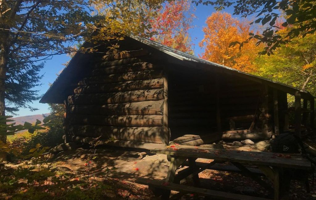
Where to Sleep: Camping, Shelters, and Hostels
There are over 70 overnight sites along the trail, located about 8 to 10 miles apart. These break down into:
- Tent sites with wooden platforms
- Lean-to shelters that fit 6 to 10 people
- Enclosed lodges with wooden bunks for up to 24 people
All sites are conveniently located near water sources and come with their own privy. The majority of shelters and lodges are free, but a handful cost a nominal fee of $5 per night which is used to fund the GMC's Caretaker Program.
Given the generous amount of facilities available along the trail, you may be tempted to leave your tent at home, but don't. The shelters and lodges are first-come-first-serve, and they fill up rapidly, especially during peak season. So, make sure you're prepared to sleep in the wild.
For those of you that'd prefer the comfort of a hostel, here are a few recommendations:
- The Green Mountain House is a hiker favorite known for its friendly owners and clean accommodations. The hostel is located at the 54-mile mark in Manchester VT and is 5 miles off the LT and AT.
- The Twelve Tribes religious group also offers the Yellow Deli hostel in Rutland where you can stay for free if you don't mind helping out with chores.
- Another well-known hostel is the ReTribe hiker hostel which has laundry facilities, shared and private rooms and a kitchenette. It is located in the Mount Mansfield area.

How to Resupply: Food, Water, and Towns
Towns are abundant along the trail, which means you'll have easy access to food, gear and supplies and should never have to carry more than four to five days of food in your pack. Mail drops are certainly possible, but most people don't use them because the trail towns have everything you need.
The Long Trail is well known among locals who are used to helping hikers get to and back from towns. A few locations also offer shuttle services that travel between trailheads and towns.
Make sure you secure your food and scented items to protect them from bears and other animals frequenting the area. For this purpose, it's always a good idea to carry a bear canister or a bear bag in case one of the campsites doesn't have a bear box.
As for water, you'll find it in abundance throughout the hike as all overnight sites have been strategically built near water sources. Just be sure to treat it before drinking or cooking with it.
If you need to acquire or replace gear, you can visit one of four outfitters available on the trail (listed from South to North):
| OUTFITTER | TOWN | WEBSITE |
|---|---|---|
| Nature’s Closet | Williamston, MA | https://naturescloset.net |
| Mountain Goat | Manchester, VT | https://www.mountaingoat.com |
| EMS | Manchester, VT | https://www.ems.com |
| Umiak Outdoor Outfitters | Stowe, VT | https://www.umiak.com |

© J & K
Sights: Nature and Wildlife
Much of the Long Trail is a green tunnel, but there are three notable alpine zones at Mount Mansfield, Camel's Hump and Mount Abraham. From these vistas, the views are outstanding. There's also many knobs, bluffs and spur trails that lead to additional scenic viewpoints.
While hiking, you may encounter a wide variety of animals like foxes, deer, moose, or ruffed grouse. Black bears are also present in Vermont, but they tend to stay away from crowds and it is unlikely you'll see one.
Finally, don't forget to look up as you may catch a glimpse of a pileated woodpecker, a bald eagle or a peregrine falcon.

Frequently Asked Questions
Is the Long Trail difficult?
Although the Long Trail is relatively short and low, it remains a challenging thru-hike. You'll want to prepare for an end-to-end hike with a few 10+ mile multi-day backpacking trips.
The Long Trail was built before trail design was a thing. Therefore, most of the climbs go straight up the mountains and don't use switchbacks to ease the steepness of an ascent. Factor in the muddy soil, the eroded pathways, and the constant ups and downs and you will find that the Long Trail is very deserving of its name.
Are dogs allowed on the Long Trail?
Yes, dogs are allowed on the Long Trail. Note that you will be required to hold them on a leash in areas where the flora is particularly fragile (ie. Alpine zones).

Additional Resources
- Trail Town Amenities Southbound (full list)
- Long Trail Lodging and Outfitters (full list)
- Long Trail Facebook Group
- Green Mountain Club website
We're curious... have you thru-hiked the Long Trail? Any tips you care to share?

 650-Calorie Fuel